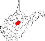
Corley, Braxton County, West Virginia
Unincorporated community in West Virginia, United States
38°44′12″N 80°35′58″W / 38.73667°N 80.59944°W / 38.73667; -80.59944Corley is an unincorporated community in Braxton County, West Virginia, United States. Corley is located along Saltlick Creek and County Route 22, 2.9 miles (4.7 km) east-northeast of Flatwoods.[2]
The community was named after a local merchant.[3]
References
- ^ U.S. Geological Survey Geographic Names Information System: Corley, Braxton County, West Virginia
- ^ Braxton County, West Virginia General Highway Map (PDF) (Map). West Virginia Department of Transportation. 2011. p. 1. Archived from the original (PDF) on April 25, 2012. Retrieved October 14, 2011.
- ^ Kenny, Hamill (1945). West Virginia Place Names: Their Origin and Meaning, Including the Nomenclature of the Streams and Mountains. Piedmont, WV: The Place Name Press. p. 186.
- v
- t
- e
Municipalities and communities of Braxton County, West Virginia, United States
County seat: Sutton

communities
- Arnett
- Bison
- Bonnie
- Canfield
- Caress
- Centralia
- Chapel
- Clem
- Copen
- Corley
- Cutlips
- Dingy
- Duck
- Dutch
- Elmira
- Falls Mill
- Flower
- Frametown
- Gem
- Gip
- Glendon
- Heaters
- Herold
- Home
- Hyers
- Joppa
- Laurel Fork
- Letch
- Little Birch
- Little Otter
- McNutt
- Napier
- Newville
- Orlando‡
- Riffle
- Rollyson
- Rosedale
- Servia
- Strange Creek
- Tague
- Tesla
- Thrash
- Vernon
- Waggy‡
- Wilsie
‡This populated place also has portions in an adjacent county or counties
- West Virginia portal
- United States portal
 | This article about a location in Braxton County, West Virginia is a stub. You can help Wikipedia by expanding it. |
- v
- t
- e


