Cartography of Dublin
Historical maps of Dublin, Ireland
The Cartography of Dublin is the history of surveying and creation of maps of the city of Dublin in Ireland. The following is a list of notable historical maps of Dublin City and County Dublin.
| Year | Name | Cartographer/Publisher | Notes | Image |
|---|---|---|---|---|
| 1610 | Dubline | John Speed | Size 21 cm x 18 cm. | 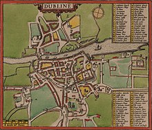 |
| 1673 | The city and suburbs of Dublin, from Kilmainham to Rings-End wherein the rivers, streets, lanes, alleys, churches, gates & c. are exactly described | Bernard de Gomme | Scale 1760 yards to 1 English mile. | |
| 1685 | An exact survey of the city of Dublin, and part of the harbour; anno 1685 | Thomas Phillips | Scale 604 feet to an inch |
|
| 1714 | Dublin | Herman Moll |
| |
| 1728 | A map of the city and suburbs of Dublin | Charles Brooking |
| |
| 1756 | Exact survey of the city and suburbs of Dublin | John Rocque | Produced on 4 sheets, each 705x495 mm. Scale 1:2400. Revised edition in 1773. |
|
| 1757 | A Survey of the city harbour and environs of Dublin | John Rocque | Size: 972 x 1390 W: 1008 x 1396. |
|
| 1760 | An actual survey of the county of Dublin | John Rocque | ||
| 1764 | Plan De La Ville De Dublin | Jacques-Nicholas Bellin | Published by Le Petit Atlas Maritime. |
|
| 1767 | Exact survey of the city and suburbs of Dublin | Published by Peter Wilson | Size 34 cm x 23 cm. Scale of British feet 3 cm to 1000 feet. Published by Peter Wilson of Dame Street. | |
| 1780 | Pool and Cash's Dublin | Robert Pool and John Cash | Panorama view of Dublin. | |
| 1782 | John Robertson's plan of the city of Dublin | John Robertson | From the Universal Scots Almanack |
|
| 1783 | Plan of Dublin from Watson's Almanack 1783 | (Later known as the Treble Alamanack) |
| |
| 1797 | Plan of Greater Dublin including Circular Roads | Engraved by Samuel John Neele. Published by: William Faden. | Plan of the city of Dublin as surveyed for the use of the Divisional Justices to which have been added plans of the canal. Engraved by S. J. Neele, 52, Strand. Published by: W. Faden, Geographer to the King, Charing Cross, 2 January 1797. Sold by: W. Allen & J. Archer, Dublin. | 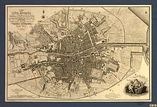 |
| 1798 | Modern Plan of the City and Environs of Dublin | William M Wilson |
| |
| 1799 | Browrigg's Map 5th Division of Dublin | |||
| 1811 | Thomas Campbell's map of the City of Dublin | |||
| 1812 | WDD New and Improved Plan of the Society of the Diffusion of Useful Knowledge | William Corbet of SDUK |
| |
| 1816 | Taylor's Environs of Dublin | John Taylor | Scale 2 inches to 1 mile. Kieran Swords says Taylor had a "cavalier attitude to territorial boundaries in County Dublin where he ignored civil parishes and where his barony boundaries are very sketchy".[1] | |
| 1818 | Plan of Dublin |
| ||
| 1821 | Maps of the county of Dublin | William Duncan | 8 sheets. Duncan was commissioned by the Dublin Grand Jury to produce a set of maps of Dublin for administrative and planning uses. | Southern 4 sheets [layer "Duncan (1821)"] |
| 1836 | Dublin Street Directory Map with engravings of the principal buildings in Dublin | Published by Baldwin & Cradock of SDUK | Published under the superintendence of the Society of the Diffusion of Useful Knowledge. Colour map. | 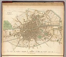
|
| 1837 | Dublin Environs | Drawn by B. R. Davies. Published by SDUK | Published under the superintendence of the Society of the Diffusion of Useful Knowledge. | 
|
| 1840 | Pettigrew and Oulton's Dublin Directory |
| ||
| 1843 | Ordnance Survey 6-inch First Edition | Ordnance Survey | Scale 6 inches to 1 mile. |
|
| 1848 | Dublin. The General Post Office Directory |
| ||
| 1848 | Environs of Dublin | S. Orr and Co, Amen Corner, London |
| |
| 1851 | General Map of the Environs of Dublin and parts of Wicklow |
| ||
| 1852 | Dublin Street Directory Map showing the boundaries of several wards | Size: 40.5 cm x 28 cm. Scale: 4 and one-eighth inches to one statute mile. General Post Office Directory. Colour map |
| |
| 1863 | Dublin showing the Boundaries of several Wards. Engraved for the General Post Office. | Published by Alex Thom, 87 Abbey St |
| |
| 1865 | Dublin Parish Maps | |||
| 1872 | Dublin by Harper's Handbook |
| ||
| 1880 | Ordnance Survey Map of the City and its Environs | Ordnance Survey | Constructed for Thom's Almanac and Official Directory. Printed and published by Alexander Thom, 87 & 88 Abbey Street, Dublin. Under direction of Lt Colonel Martin. Scale 6 inches to 1 mile. |
|
| 1885 | Plan of Dublin |
| ||
| 1885 | Environs of Dublin | By Edward Weller F.R.G.S. |
| |
| 1888 | German map of Dublin |  | ||
| 1893 | Insurance Plan of the City of Dublin | Charles E. Goad | ||
| 1895 | Bacon's Large Scale Plan of Dublin for Cyclists and Tourists | Published by G.W. Bacon and Co., London | Size 82 cm x 70 cm. Scale 6" : 1 mile. Publish by company of George Washington Bacon (1830–1922). |
|
| 1906–9 | Ordnance Survey 25-inch Second Edition | Ordnance Survey | Scale 1:2500 (c.25 inches to 1 mile). |
|
| 1912 | Dublin City | Published by A&C Black, London |
| |
| 1913 | Plan of Dublin |
|
References
- ^ Swords, Kieran (1997). "Ballyroan Townland, Delineation and Decline: Part 2". Dublin Historical Record. 50 (1): 55–70: 56. ISSN 0012-6861. JSTOR 30101159.
External links
Wikimedia Commons has media related to Old maps of Dublin.
- http://www.logainm.ie/eolas/Data/IHTA/dublin-2.pdf
- http://libguides.ucd.ie/mapshistDublin
- http://gis.sdublincoco.ie/historical_mapping/map_descriptions.html
- https://web.archive.org/web/20120203092223/http://gis.sdublincoco.ie/historical_mapping/ – South Dunblin CoCo area – online maps for Roque (1760), Taylor (1816), Duncan (1821), First Edition OS Maps (1843), Third Edition OS Maps (1911–12), Fourth Edition OS Maps (1935–38), GSGS 3906 (1940) and GSGS 4136 (1942).
- Maps of Dublin accompanying Thom's Official Directory, printed by the Ordnance Survey for the Dublin publisher Alexander Thom from the six-inch map sheets 18 and 22, and dating from the late 19th century. A UCD Digital Library Collection.
- v
- t
- e
Cartography topics
| Ancient age |
|
|---|---|
| Middle age |
|
| Early Modern age |
|
| Contemporary age | |
| See also |


