Calderpark Halt railway station
Disused railway station in Scotland
55°50′13″N 4°06′36″W / 55.837°N 4.110°W / 55.837; -4.110
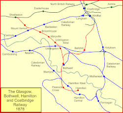
Calderpark Halt railway station[1][2] or Calderpark for Glasgow Zoo[3] (NS679625) served Calderpark Zoo opened in 1947 on the old estate of Calderpark and the Baillieston area of Glasgow, Scotland on the Glasgow, Bothwell, Hamilton and Coatbridge Railway between Shettleston and Hamilton. Glasgow Zoo closed in 2003.
History
The halt was opened by the British Transport Commission to serve Glasgow Zoo in 1951[1] on the Glasgow, Bothwell, Hamilton and Coatbridge Railway route by Mrs Cameron wife of British Railway's Chief Regional Officer for the area.[3]
The route was also known as the London and North Eastern Railway's Hamilton Branch. It was closed when the line was closed to passenger traffic on 4 July 1955.[1] The line was closed to freight traffic on 4 October 1964.
Infrastructure
The halt had a name board that read 'Calderpark for the Zoo', had electric lighting, two concrete platforms with simple brick built shelters and toilets on the northern side with sloping concrete roofing on a double track section of track standing just to the west of the North Calder Viaduct. The Calderpark Viaduct lay to the west. The remains of the halt on the dismantled line are shown with two shelters on the south side of the line in a low cutting just off Baillieston Road.[4]
Remains on site
Glasgow Zoo closed in 2003 and eventually the buildings were demolished and replaced by a housing estate (part of Broomhouse). The site of Calderpark Halt has become Calderpark Terrace and the only remains are at the site of the old North Calder Viaduct.
Services
| Preceding station | Disused railways | Following station | ||
|---|---|---|---|---|
| Broomhouse | North British Railway Glasgow, Bothwell, Hamilton and Coatbridge Railway | Maryville |
References
Notes
Sources
- Butt, R. V. J. (October 1995). The Directory of Railway Stations: details every public and private passenger station, halt, platform and stopping place, past and present (1st ed.). Sparkford: Patrick Stephens Ltd. ISBN 978-1-85260-508-7. OCLC 60251199. OL 11956311M.
- Jowett, Alan (March 1989). Jowett's Railway Atlas of Great Britain and Ireland: From Pre-Grouping to the Present Day (1st ed.). Sparkford: Patrick Stephens Ltd. ISBN 978-1-85260-086-0. OCLC 22311137.
- v
- t
- e
Railway stations and subway stations in Glasgow
- Anderston
- Argyle Street
- Charing Cross
- Glasgow Central
- Glasgow Queen Street
- High Street
- Alexandra Parade
- Anniesland
- Ashfield
- Baillieston
- Barnhill
- Bellgrove
- Bridgeton
- Cardonald
- Carmyle
- Carntyne
- Cathcart
- Corkerhill
- Croftfoot
- Crookston
- Crosshill
- Crossmyloof
- Dalmarnock
- Drumchapel
- Drumry
- Duke Street
- Dumbreck
- Easterhouse
- Exhibition Centre
- Garrowhill
- Garscadden
- Gilshochill
- Hillington East
- Hillington West
- Hyndland
- Jordanhill
- Kelvindale
- Kennishead
- King's Park
- Langside
- Maryhill
- Maxwell Park
- Mosspark
- Mount Florida
- Mount Vernon
- Muirend
- Nitshill
- Partick
- Pollokshaws East
- Pollokshaws West
- Pollokshields East
- Pollokshields West
- Possilpark & Parkhouse
- Priesthill & Darnley
- Queen's Park
- Robroyston
- Scotstounhill
- Shawlands
- Shettleston
- Springburn
- Summerston
- Bellahouston
- Bellahouston Park Halt
- Botanic Gardens
- Bridge Street
- Bridgeton Central
- Buchanan Street (mainline)
- Calderpark Halt
- College
- Crow Road
- Cumberland Street
- Dawsholm
- Dunlop Street
- Eglinton Street
- Finnieston
- Gallowgate
- Gallowgate Central
- Garngad
- Glasgow Cross
- Glasgow Green
- Gorbals
- Govan
- Hyndland
- Ibrox
- Kelvinbridge
- Kelvinside
- Kirklee
- Main Street
- Maryhill Central
- Merkland Street
- Mount Vernon North
- Parkhead Stadium (GCR)
- Parkhead North (NBR)
- Partick Central
- Partickhill
- Partick West
- Pollokshields
- Possil
- Shields
- Shields Road
- Southside
- St Enoch (mainline)
- Strathbungo
- Tollcross
- Whiteinch Victoria Park
 | This Glasgow railway station-related article is a stub. You can help Wikipedia by expanding it. |
- v
- t
- e


