Burg Raabs an der Thaya
You can help expand this article with text translated from the corresponding article in German. (July 2009) Click [show] for important translation instructions.
- View a machine-translated version of the German article.
- Machine translation, like DeepL or Google Translate, is a useful starting point for translations, but translators must revise errors as necessary and confirm that the translation is accurate, rather than simply copy-pasting machine-translated text into the English Wikipedia.
- Do not translate text that appears unreliable or low-quality. If possible, verify the text with references provided in the foreign-language article.
- You must provide copyright attribution in the edit summary accompanying your translation by providing an interlanguage link to the source of your translation. A model attribution edit summary is
Content in this edit is translated from the existing German Wikipedia article at [[:de:Burg Raabs an der Thaya]]; see its history for attribution. - You may also add the template
{{Translated|de|Burg Raabs an der Thaya}}to the talk page. - For more guidance, see Wikipedia:Translation.
| Burg Raabs an der Thaya | |
|---|---|
| Raabs an der Thaya, Lower Austria, Austria | |
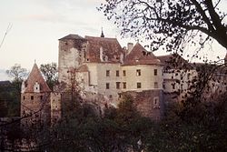 View from the north | |
| Type | Castle |
Burg Raabs an der Thaya is a castle in municipality Raabs an der Thaya, Lower Austria, Austria, built in the second half of the 11th century, it is 456 metres (1,496 ft) above sea level.[1]
History
The medieval history of this area begins with the old Moravian fortification in the Sand location, near Burg Raabs. This fortified settlement was discovered in 1992 by Kurt Bors. According to the results of dendrochronological dating, the Northern Wall was built between 926 and 929. However, the settlement was abandoned after several decades, probably destroyed by catastrophic fire by the Hungarian raid. Prior to being overthrown by the Hungarians, the Great Moravian Empire ruled today's Lower Austria, up to Enns river. The first written records related to the lord of the castle "Gotfridi in castrum Racouz" is in Bohemian Cosmas Chronicle from 1100. From the years 1074 and 1076 are named forest areas "silva Rogacz" ("Rogacz forest" - territory around the later town Horn), they are named in two royal gifts for the margraves of the Babenberg family.
The castle has been called Rakous (formerly Rakús) by neighbouring Czechs, which is the origin of the Czech and Slovak name for Austria as a whole, Rakousko/Rakúsko.
Instability in South Moravian space in the first half of the 11th century led to repeated conflicts. For example, in the Altahensis annales it is recorded that in 1082 the son of Margrave Adalbert took one of the towns at the present northern provincial border after it was forcibly taken from his father by the Přemyslids. After the extinction of the Raab Counts in the male line (around 1192) the western territory with the castle passed to Count Hirschberg-Tollenstein.
In 1252, Bohemian King Přemysl Otakar II acquired the whole county. Owner of the castle became Vok I. of Rožmberk from Bohemian noble clan Vítkovci. In 1282, the Castle passed to Habsburgs, because after 1278 a large part of the county was confiscated by King Rudolf.
See also
References
- ^ Burg Raabs an der Thaya Altitude and Location
- v
- t
- e


- Burgruine Aichelburg
- Klosterruine Arnoldstein
- Burgruine Dietrichstein
- Burgruine Falkenstein (Oberfalkenstein)
- Burg Falkenstein (Niederfalkenstein)
- Burgruine Feldsberg
- Burgruine Federaun
- Burgruine Finkenstein
- Burgruine Flaschberg
- Burg Freiberg
- Burg Geyersberg
- Burgruine Glanegg
- Burgruine Gmünd
- Burgruine Goldenstein
- Burgruine Gomarn
- Burgruine Gradenegg
- Burgruine Grafenstein
- Burgruine Greifenfels
- Burgruine Griffen
- Burgruine Groppenstein
- Burgruine Grünburg
- Burgruine Gurnitz
- Burg Haimburg
- Burgruine Hardegg
- Burgruine Hartneidstein
- Burgruine Himmelberg
- Burg Hochosterwitz
- Burgruine Hohenburg
- Burgruine Hohenburg auf Rosenberg
- Burgruine Hohenwart
- Schloss Hollenburg
- Burgruine Karlsberg
- Burgruine Kühnburg
- Burgruine Landskron
- Burgruine Lavant
- Burgruine Leobenegg
- Burgruine Leonstein
- Burgruine Lichtengraben/Painburg
- Burgruine Liemberg
- Burgruine Liebenfels
- Burg Mannsberg
- Burgruine Moosburg/Arnulfsfeste
- Burg Neudenstein
- Burgruine Nussberg
- Burgruine Ortenburg
- Burgruine Petersberg
- Burgruine Prägrad
- Burgruine Rabenstein
- Burgruine Ras
- Burgruine Rauchenkatsch
- Burgruine Rauterburg
- Burgruine Rechberg
- Burgruine Reifnitz
- Burgruine Reinegg
- Burgruine Reisberg
- Burgruine Rosegg
- Burgruine Rothenthurn
- Burgruine Rottenstein
- Burgruine Schaumburg
- Burgruine Silberberg
- Burg Sommeregg
- Burgruine Sonegg
- Burgruine Sternberg
- Burgruine Steuerberg
- Burg Straßburg
- Burgruine Straßfried
- Burgruine Taggenbrunn
- Burgruine Treffen
- Burgruine Twimberg
- Burgruine Waisenberg
- Burgruine Weidenburg
- Burgruine Weißenegg
- Burgruine Wullroß
- Burgruine Aggstein
- Burgruine Araburg
- Burgruine Dobra
- Burgruine Dürnstein
- Castle Falkenstein (Lower Austria)
- Franzensburg
- Burg Greifenstein
- Burg Grub
- Burg Hardegg
- Burg Hartenstein
- Burg Heidenreichstein
- Burgruine Kaja
- Burg Karlstein
- Burgruine Kollmitz
- Burg Kreuzenstein
- Burg Liechtenstein
- Burgruine Mödling
- Burg Neulengbach
- Burg Ottenstein
- Burg Perchtoldsdorf
- Burg Plankenstein
- Burg Persenbeug
- Burg Raabs an der Thaya
- Burg Rappottenstein
- Burgruine Rauheneck (Baden)
- Burgruine Rauhenstein
- Rosenburg
- Schallaburg
- Burg Scharfeneck
- Burg Seebenstein
- Burgruine Senftenberg
- Burgruine Starhemberg
- Schloss Walpersdorf
- Burg Wiener Neustadt
- Burg Alt-Teuffenbach
- Burg Baiersdorf
- Burg Deutschlandsberg
- Burg Dürnstein
- Schloss Eggenberg (Graz)
- Burg Ehrenfels (St. Radegund)
- Schloss Ehrenhausen
- Burgruine Eppenstein
- Schloss Feistritz / Ilz
- Burg Festenburg
- Burgruine Fohnsdorf
- Burg Forchtenstein
- Frauenburg (castle)
- Schloss Frondsberg
- Burgruine Gallenstein
- Schloss Gleichenberg
- Schloss Grosssölk
- Burg Grünfels
- Schloss Gutenberg
- Ruine Hauenstein
- Ruine Henneberg
- Schloss Herberstein
- Ruine Hohenwang
- Burg Kammerstein/ Ehrenfels
- Ruine Kalsberg
- Burg Kaisersberg
- Ruine Katsch
- Ruine Klingenstein /Salla
- Ruine Klöch
- Burg Krems
- Ruine Ligist
- Burg Neuberg
- Burg Neuhaus bei Stubenberg
- Ruine Neu-Leonroth
- Burg Lichtenegg
- Ruine Liechtenstein
- Ruine Neudeck
- Burg Oberkapfenberg
- Burg Obervoitsberg
- Ruine Offenburg
- Ruine Pernegg
- Ruine Pflindsberg
- Burgruine Pfannberg
- Burgruine Pikeroi
- Ruine Puxer-Loch
- Ruine Raabeck
- Schloss Rabenstein
- Burgruine Reifenstein
- Riegersburg Castle
- Burg Schachenstein
- Ruine Schmirnberg
- Schloss Seggau
- Burgruine Steinschloß
- Burgruine Sturmberg
- Burg Thalberg
- Burg Waldstein
- Burgruine Waxenegg
- Burgruine Wildon
- Burgruine Wolkenstein
Also See: Castles in Austria
| Authority control databases |
|
|---|
48°51′0″N 15°29′0″E / 48.85000°N 15.48333°E / 48.85000; 15.48333
 | This Lower Austria location article is a stub. You can help Wikipedia by expanding it. |
- v
- t
- e
  | This article about a castle in Austria is a stub. You can help Wikipedia by expanding it. |
- v
- t
- e


