Brokenhead Wetland Ecological Reserve
Protected area in Manitoba, Canada
| Brokenhead Wetland Ecological Reserve | |
|---|---|
IUCN category Ia (strict nature reserve)[1] | |
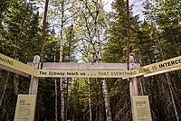 Entrance to the Brokenhead Wetland Interpretive Trail | |
| Location | 1 km south of and 12, 59 Provincial Trunk Hwy 12, Beaconia, MB R0E 0B0 |
| Area | 1,240 ha (4.8 sq mi) |
| Established | 2005 |

Brokenhead Wetland Ecological Reserve
Brokenhead Wetland Ecological Reserve is an ecological reserve northeast of Scanterbury, Manitoba, Canada.[2] It was established in 2005 under the Manitoba Ecological Reserves Act.[1][3] It is 12.4 square kilometres (4.8 sq mi) in size.[1]
Flora

According to the Government of Manitoba's informational PDF about the site,
The reserve contains 23 species of provincially rare and uncommon plants. Twenty-eight of Manitoba’s 36 native orchid species, including the rare ram’s head lady’s-slipper, are found in the wetland along with eight of Manitoba’s 10 species of carnivorous (insect-eating) plants. A rare white cedar community also forms part of the wetland area.[2]
Among the carnivorous plants found in the reserve are the purple pitcher-plant, common butterwort, sundew and common bladderwort. The reserve includes a calcareous fen, a habitat that is essential to the survival of the rare plant species.[4]
Conservation
According to the Government of Manitoba's informational PDF about the site,
Manitoba Conservation and Water Stewardship has partnered with Debwendon Inc. to create an interpretive trail and boardwalk on the Crown land adjacent to the ecological reserve. This was also made possible through funding support from the Eugene Reimer Environment Fund at The Winnipeg Foundation. The installation of the boardwalks and interpretive signage allows the public to safely visit the area for aesthetic, educational and cultural reasons without causing further damage to the native plants and their habitat.[2]
See also
References
- ^ a b c "Brokenhead Wetland Ecological Reserve". Protected Planet. IUCN. Retrieved 26 December 2019.
- ^ a b c "Brokenhead Wetland Ecological Reserve, Backgrounder" (PDF). Government of Manitoba. Retrieved 22 July 2022.
- ^ "Ecological Reserves". www.gov.mb.ca. Government of Manitoba. Retrieved 22 July 2022.
- ^ "Brokenhead Wetlands Special Field Day – June 22, 2012" (PDF). nativeorchid.org. Archived from the original (PDF) on 25 April 2016.
External links
- debwendon: Brokenhead Wetland
- iNaturalist: Brokenhead Wetland Ecological Reserve
- v
- t
- e
- Asessippi
- Atikaki
- Bakers Narrows
- Beaudry
- Beaver Creek
- Bell Lake
- Birch Island
- Birch Point
- Birds Hill
- Burge Lake
- Camp Morton
- Caribou River
- Chitek Lake Anishinaabe
- Clearwater Lake
- Colvin Lake
- Criddle/Vane Homestead
- Duck Mountain
- Duff Roblin
- Elk Island
- Fisher Bay
- Grand Beach
- Grand Rapids
- Grand Valley
- Grass River
- Hecla-Grindstone
- Hnausa Beach
- Hyland
- Kettle Stones
- Kinwow Bay
- Lake St. Andrew
- Lake St. George
- Little Limestone Lake
- Lockport
- Lundar Beach
- Manigotagan River
- Manipogo
- Marchland
- Margaret Bruce
- Memorial
- Moose Lake
- Neso Lake
- Netley Creek
- Nopiming
- Norris Lake
- North Steeprock Lake
- Nueltin Lake
- Numaykoos Lake
- Oak Lake
- Overflowing River
- Paint Lake
- Patricia Beach
- Pembina Valley
- Pinawa Dam
- Pinawa
- Pisew Falls
- Poplar Bay
- Portage Spillway
- Primrose
- Rainbow Beach
- Red Deer River
- River Road
- Rivers
- Rocky Lake
- Sand Lakes
- Sasagiu Rapids
- Seton
- South Atikaki
- Springwater
- Spruce Woods
- St. Ambroise Beach
- St. Malo
- St. Norbert
- Stephenfield
- Sturgeon Bay
- Swan River
- Trappest Monastery
- Turtle Mountain
- Twin Lakes
- Upper Fort Garry Heritage
- Wallace Lake
- Watchorn
- Wekusko Falls
- Whitefish Lake
- Whitemouth Falls
- Whiteshell
- William Lake
- Winnipeg Beach
- Woodridge
- Yellow Quill
- Zed Lake
- Agassiz
- Belair
- Brightstone Sand Hill
- Cat Hills
- Cormorant
- Duck Mountain
- Moose Creek
- Northwest Angle
- Porcupine
- Sandilands
- Spruce Woods
- Swan-Pelican
- Turtle Mountain
- Wampum
- Whiteshell
- Armit Meadows
- Baralzon Lake
- Birch River
- Brokenhead River
- Brokenhead Wetland
- Cedar Bog
- Cowan Bog
- Holmgren Pines
- Jennifer and Tom Shay
- Kaweenakumik Islands
- Lake St. George Caves
- Lake Winnipegosis Salt Flats
- Lewis Bog
- Libau Bog
- Little George Island
- Long Point
- Palsa Hazel
- Pelican Islands
- Piney
- Pocock Lake
- Red Rock
- Reindeer Island
- Ste. Anne Bog
- St. Labre Bog
- Walter Cook Caves
- Wampum
- Whitemouth Bog
- Whitemouth Island
- Whitemouth River
- Woodridge
- Alonsa
- Assiniboine Corridor
- Basket Lake
- Bernice
- Brandon Hills
- Broad Valley
- Broomhill
- C. Stewart Stevenson
- Catfish Creek
- Cayer
- Churchill
- Delta Marsh
- Deerwood
- Dog Lake
- Ebor
- Gerald W. Malaher
- Grant's Lake
- Gypsumville
- Harrison
- Hilbre
- Holmfield
- Kasatamagan Sipi
- Kasatamagan
- Lake Francis
- Langruth
- Lauder Sandhills
- Lee Lake
- Lee River
- Little Birch
- Little Saskatchewan
- Manatagao
- Maple Lake
- Mars Hill
- Marshy Point
- Moose Creek
- Narcisse
- Oak Hammock Marsh
- Observation Point
- Oranole
- Otter Lake
- Parkland
- Pembina Valley
- Penonan Point
- Pierson
- Point River
- Portage Sandhills
- Proven Lake
- Proulx Lake
- Rat River
- Red Deer
- Riverside
- Saskeram
- Sleeve Lake
- Souris River Bend
- Spruce Woods
- Spur Woods
- St. Malo
- Steeprock
- Stuartburn
- Thalberg Bush
- Tiger Hills
- Tom Lamb
- Turtle Mountain
- Upper Assiniboine
- Wakopa
- Washow Bay
- Watson P. Davidson
- Weiden
- Wellington
- Westlake
- Whitemouth Bog
- Whitemud Watershed
- Whitewater Lake
World Biosphere Reserves
- Assiniboine
- Bruce
- Central
- Kil-Cona
- Kildonan
- King's
- Living Prairie Museum
- Maple Grove
- St. Vital
- Stephen Juba
 Category
- Conservation Districts
- Parks Canada
 Commons

50°23′17″N 96°33′32″W / 50.388°N 96.559°W / 50.388; -96.559


