Bayraklı
District and municipality in İzmir, Turkey
38°27′44″N 27°10′0″E / 38.46222°N 27.16667°E / 38.46222; 27.16667 (2022)[1]
Bayraklı is a municipality and district of İzmir Province, Turkey.[2] Its area is 30 km2,[3] and its population is 298,519 (2022).[1] It covers the northern part of the metropolitan area of İzmir. The district of Bayraklı was created in 2008 from part of the district of Karşıyaka.[4][5]
Composition
There are 24 neighbourhoods in Bayraklı District:[6]
- 75. Yıl
- Adalet
- Alparslan
- Bayraklı
- Çay
- Cengizhan
- Çiçek
- Doğançay
- Emek
- Fuat Edip Baksi
- Gümüşpala
- Körfez
- Manavkuyu
- Mansuroğlu
- Muhittin Erener
- Onur
- Org. Nafiz Gürman
- Osman Gazi
- Postacılar
- Refik Şevket Ince
- Soğukkuyu
- Tepekule
- Turan
- Yamanlar
See also
References
- ^ a b "Address-based population registration system (ADNKS) results dated 31 December 2022, Favorite Reports" (XLS). TÜİK. Retrieved 12 July 2023.
- ^ Büyükşehir İlçe Belediyesi, Turkey Civil Administration Departments Inventory. Retrieved 12 July 2023.
- ^ "İl ve İlçe Yüz ölçümleri". General Directorate of Mapping. Retrieved 12 July 2023.
- ^ Kanun No. 5747, Resmî Gazete, 22 March 2008.
- ^ "İl İdaresi ve Mülki Bölümler Şube Müdürlüğü İstatistikleri - İl ve İlçe Kuruluş Tarihleri" (PDF) (in Turkish). p. 44. Retrieved 12 September 2023.
- ^ Mahalle, Turkey Civil Administration Departments Inventory. Retrieved 12 July 2023.
- v
- t
- e
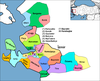
Bayraklı in Izmir Province of Turkey

| Istanbul | |
|---|---|
| West Marmara | |
| Aegean | |
| East Marmara | |
| West Anatolia | |
| Mediterranean | |
| Central Anatolia | |
| West Black Sea | |
| East Black Sea | |
| Northeast Anatolia | |
| Central East Anatolia | |
| Southeast Anatolia | |
Metropolitan municipalities are bolded.
| |||||||
|---|---|---|---|---|---|---|---|
Known as Smyrna in English until about 1930 | |||||||
| Settlements |
| ||||||
| History | |||||||
| Universities | |||||||
| Museums and monuments |
| ||||||
| Religious buildings |
| ||||||
| Transportation | |||||||
| Buildings and structures | |||||||
| Squares | |||||||
 Category:İzmir Category:İzmir | |||||||

| Authority control databases: National |
|
|---|
 | This geographical article about a location in İzmir Province, Turkey is a stub. You can help Wikipedia by expanding it. |
- v
- t
- e


