Ballymakeera
Village in County Cork, Ireland
Village in Munster, Ireland
Ballymakeera Baile Mhic Íre | |
|---|---|
Village | |
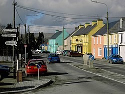 Baile Mhic Íre on the N22 | |
| 51°56′08″N 9°08′37″W / 51.93558°N 9.143667°W / 51.93558; -9.143667 | |
| Country | Ireland |
| Province | Munster |
| County | County Cork |
| Elevation | 118 m (387 ft) |
Ballymakeera or Ballymakeery (Irish: Baile Mhic Íre [ˈbˠalʲə vʲɪc ˈiːɾʲə], meaning "Townland of the Sons of Íre")[1] is a small townland and Gaeltacht village in the civil parish of Ballyvourney, barony of Muskerry West, County Cork, Ireland.
The village, which in turn has postal addresses of Ballymakeera East and Ballymakeera West, forms part of the twin villages of Ballymakeery and Ballyvourney. The village is situated in the valley of the River Sullane on the N22 national primary road. It is within the Muskerry Gaeltacht. Ballymakeera is part of the Dáil constituency of Cork North-West.
Three Ogham stones are nearby with the somewhat later addition of a Christian shrine to St Abán.[2]
Notable people
The sean-nós singer Elizabeth Cronin lived in the village.[citation needed]
References
See also
- v
- t
- e
| Ulster |
| ||||||
|---|---|---|---|---|---|---|---|
| Connacht |
| ||||||
| Munster |
| ||||||
| Leinster |
| ||||||
| See also |
|
- Údarás na Gaeltachta
- Gaeltarra Éireann
- Coimisiún na Gaeltachta
- Department of Tourism, Culture, Arts, Gaeltacht, Sport and Media
- Saor Raidió Chonamara
- RTÉ Raidió na Gaeltachta
- TG4
- Acadamh na hOllscolaíochta Gaeilge
- Taibhdhearc na Gaillimhe
- Gluaiseacht Chearta Sibhialta na Gaeltachta
- Muintir na Gaeltachta
- An Coimisinéir Teanga
- Connemara
- Conradh na Gaeilge
- Bean an tí
- Gaelic revival
- Gaels
- Gaeltacht Act 2012
- Gaeltacht service town
- Gàidhealtachd
- Minister for Tourism, Culture, Arts, Gaeltacht, Sport and Media
- Minister of State at the Department of Tourism, Culture, Arts, Gaeltacht, Sport and Media
- Official Languages Act 2003
- Sean-nós singing

 | This geographical article about County Cork is a stub. You can help Wikipedia by expanding it. |
- v
- t
- e


