Bairoa, Caguas, Puerto Rico
Barrio of Puerto Rico
Barrio in Caguas, Puerto Rico
18°15′35″N 66°02′25″W / 18.25977°N 66.040177°W / 18.25977; -66.040177[1] Puerto Rico
 Caguas
 (2020)
00725, 00726, 00727
Bairoa is a barrio or district in the municipality of Caguas, Puerto Rico. Its population in 2020 was 18,197.[3][4][5] There are close to 60 sectors in Bairoa.
Name
The barrio of Bairoa gets its name from the Bairoa River which crosses the area from west to east and flows into the Loíza River. There are numerous theories about the name meaning of Bairoa. The word bairoa is most likely of Taíno origin and it possibly comes from the word baira, which is either the native name for the tree Chrysophyllum cainito, or a native word meaning "forest", "wood" or "tree bark", or from the word paira meaning "bow".[6][7]
Sectors and demographics
Barrios (which are, in contemporary times, roughly comparable to minor civil divisions)[8] in turn are further subdivided into smaller local populated place areas/units called sectores (sectors in English). The types of sectores may vary, from normally sector to urbanización to reparto to barriada to residencial, among others.[9][10][11]
The following sectors are in Bairoa: Alto Monte, Altos de San Luis, Antigua Planta de Tratamiento, Antigua Vía, Apartamentos Los Pinos, Arbolada, Bairoa I, Bairoa II, Bairoa La 25, Bairoa Park Bairoa, Bairoa Shopping Center, Barrio Bairoa, Caguas Milenio I, Caguas Milenio II, Caribbean Containers Bairoa, Cementerio Monte Calvario, Chalets de Bairoa, Ciudad Jardín, Ciudad Jardín - La Cima, Colinas de Bairoa, Centro Comercial San Antonio, Diamond Village, El Retiro, Estancias de Bairoa, Estancias de Santa Teresa Bairoa, Estancias del Turabo, Golden Gate I, Golden Gate II, Jardines de Condado Moderno, La Serranía, La Serranía - Lomas de La Serranía, La Serranía - Rincón de La Serranía, Las Carolinas, Las Carolinas - Urbanización Las Carolinas, Los Cajones, Los Curas, Los Reyes, Mansiones de Bairoa, Mirador de Bairoa, Monte Altos de San Luis, Monticelo, Obras Públicas Municipal, Parque Industrial Angora, Parque Industrial Bairoa, Parque Industrial Santa Elvira, Planta de Tratamiento, La 25, Plaza Centro, Santa Juana Apartments, Santa Juana I y II, Santa Juana III, Santa Juana IV, Telefónica, Valle Verde Bairoa, Valley View Park, Villa Blanca Apartments, Bairoa Walmart, and Wind Gate.[12]
| Census | Pop. | Note | %± |
|---|---|---|---|
| 1910 | 2,994 | — | |
| 1920 | 2,873 | −4.0% | |
| 1930 | 3,809 | 32.6% | |
| 1940 | 3,866 | 1.5% | |
| 1950 | 2,432 | −37.1% | |
| 1960 | 3,420 | 40.6% | |
| 1970 | 0 | −100.0% | |
| 1980 | 14,562 | — | |
| 1990 | 18,189 | 24.9% | |
| 2000 | 19,201 | 5.6% | |
| 2010 | 19,258 | 0.3% | |
| 2020 | 18,197 | −5.5% | |
| U.S. Decennial Census 1900 (N/A)[13] 1910-1930[14] 1930-1950[15] 1980-2000[16] 2010[17] 2020[5] | |||
History
The area of Bairoa was originally inhabited by the Taíno people. At the time of the Spanish arrival the area was under control of cacique (tribal chief) Caguax, from whom the city of Caguas gets its name. The first European settlement in the area was the Hato de Bairoa, a cattle farm established and developed between the years 1525 and 1600. The first mention of Bairoa as a district of Caguas comes from the colonial municipal budget documents of 1821 as Bairoa Abajo and Bairoa Arriba (modern day Bairoa, Aguas Buenas). During this time the economy of the barrio was primarily the cultivation of sugarcane and minor fruits, and cattle raising.[18]
Bairoa was in Spain's gazetteers[19] until Puerto Rico was ceded by Spain in the aftermath of the Spanish–American War under the terms of the Treaty of Paris of 1898 and became an unincorporated territory of the United States. In 1899, the United States Department of War conducted a census of Puerto Rico finding that the combined population of Borinquen barrio and Bairoa barrio was 3,870.[20] According to the 2010 United States Census the population of Bairoa is of 19,258 residents, and the barrio today is primarily suburban and residential.
Landmarks and places of interest
- Altos de La Mesa and Altos de San Luis, two mountain ridges and secondary forests home to the Puerto Rican plain pigeon.
- Bairoa Forest, secondary forest between the Valle Verde and Golden Gates neighborhoods.
- Bairoa La 25, original section of the historic Carretera Central along the Loíza River.
- Bairoa Park, baseball field and sports complex.
- Bairoa Shopping Center, one of the oldest shopping centers in Caguas.
- El Mariachi, Mexican-Puerto Rican restaurant popular with locals and visitors alike.
- Monte Calvario Cemetery, crematorium and cemetery.
- Plaza Centro Mall, former location of Central Santa Juana and a sugarcane refinery.
Gallery
-
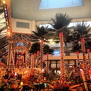 Plaza Centro, Christmas 2012.
 -
 View of Caguas and Bairoa (in the foreground) from Altos de San Luis.


See also
 Puerto Rico portal

References
- ^ a b "US Gazetteer 2019". US Census. US Government.
- ^ U.S. Geological Survey Geographic Names Information System: Bairoa barrio
- ^ Picó, Rafael; Buitrago de Santiago, Zayda; Berrios, Hector H. (1969). Nueva geografía de Puerto Rico: física, económica, y social, por Rafael Picó. Con la colaboración de Zayda Buitrago de Santiago y Héctor H. Berrios. San Juan Editorial Universitaria, Universidad de Puerto Rico,1969.
- ^ Gwillim Law (20 May 2015). Administrative Subdivisions of Countries: A Comprehensive World Reference, 1900 through 1998. McFarland. p. 300. ISBN 978-1-4766-0447-3. Retrieved 25 December 2018.
- ^ a b "Bairoa barrio, Caguas Municipio, Puerto Rico". US Census. Retrieved April 7, 2024.
- ^ Payne, D.L. (1991). Handbook of Amazonian Languages. Berlin.
{{cite book}}: CS1 maint: location missing publisher (link) - ^ "Lengua Taína Diccionario". pueblosoriginarios.com. Retrieved 2021-10-21.
- ^ "US Census Barrio-Pueblo definition". factfinder.com. US Census. Archived from the original on 13 May 2017. Retrieved 5 January 2019.
- ^ "Agencia: Oficina del Coordinador General para el Financiamiento Socioeconómico y la Autogestión (Proposed 2016 Budget)". Puerto Rico Budgets (in Spanish). Retrieved 28 June 2019.
- ^ Rivera Quintero, Marcia (2014), El vuelo de la esperanza: Proyecto de las Comunidades Especiales Puerto Rico, 1997-2004 (first ed.), San Juan, Puerto Rico Fundación Sila M. Calderón, ISBN 978-0-9820806-1-0
- ^ "Leyes del 2001". Lex Juris Puerto Rico (in Spanish). Retrieved 24 June 2020.
- ^ "Lista Sectores por Barrios Separados" (PDF). Municipio Autónomo de Caguas Oficina de Planificación Unidad de Información Geográfica y Estadísticas Vitales (in Spanish). Retrieved 7 January 2023.
- ^ "Report of the Census of Porto Rico 1899". War Department Office Director Census of Porto Rico. Archived from the original on July 16, 2017. Retrieved September 21, 2017.
- ^ "Table 3-Population of Municipalities: 1930 1920 and 1910" (PDF). United States Census Bureau. Archived (PDF) from the original on August 17, 2017. Retrieved September 21, 2017.
- ^ "Table 4-Area and Population of Municipalities Urban and Rural: 1930 to 1950" (PDF). United States Census Bureau. Archived (PDF) from the original on August 30, 2015. Retrieved September 21, 2014.
- ^ "Table 2 Population and Housing Units: 1960 to 2000" (PDF). United States Census Bureau. Archived (PDF) from the original on July 24, 2017. Retrieved September 21, 2017.
- ^ Puerto Rico: 2010 Population and Housing Unit Counts.pdf (PDF). U.S. Dept. of Commerce Economics and Statistics Administration U.S. Census Bureau. 2010. Archived (PDF) from the original on 2017-02-20. Retrieved 2019-08-02.
- ^ de Lamadrid Pesant, Katia Gil (1991). Caguas: Transformaciones territoriales desde el período colonial hasta 1952 (in Spanish). Gurabo, Puerto Rico: Universidad del Turabo.
- ^ "Anuario del comercio, de la industria, de la magistratura y de la administración. 1881". Biblioteca Nacional de España (in Spanish). p. 1614. Retrieved 4 April 2023.
- ^ Joseph Prentiss Sanger; Henry Gannett; Walter Francis Willcox (1900). Informe sobre el censo de Puerto Rico, 1899, United States. War Dept. Porto Rico Census Office (in Spanish). Imprenta del gobierno. p. 161.
External links
- Caguas government site


