Arevashat
40°08′30″N 44°22′15″E / 40.14167°N 44.37083°E / 40.14167; 44.37083
Place in Armavir, Armenia
Arevashat Արևաշատ | |
|---|---|
 Arevashat as seen from the air in the foreground | |
  Arevashat | |
| Coordinates: 40°08′30″N 44°22′15″E / 40.14167°N 44.37083°E / 40.14167; 44.37083 | |
| Country | Armenia |
| Marz (Province) | Armavir |
| Population (2008) | |
| • Total | 1,524 |
| Time zone | UTC+4 ( ) |
Arevashat (Armenian: Արևաշատ) known as Varmaziar until 1946, is a village in the Armavir Province of Armenia.
Gallery
-
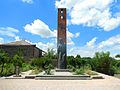 World War II memorial

See also
- Armavir Province
References
- Arevashat at GEOnet Names Server
- World Gazeteer: Armenia[dead link] – World-Gazetteer.com
- Report of the results of the 2001 Armenian Census, Statistical Committee of Armenia
- Kiesling, Brady (June 2000). Rediscovering Armenia: An Archaeological/Touristic Gazetteer and Map Set for the Historical Monuments of Armenia (PDF). Archived (PDF) from the original on 6 November 2021.
- v
- t
- e
 Armavir Province
Capital: Armavir
- Armavir
- Metsamor
- Vagharshapat

 | This article about a location in Armavir Province, Armenia is a stub. You can help Wikipedia by expanding it. |
- v
- t
- e


