Alvank
Place in Syunik, Armenia
Alvank Ալվանք | |
|---|---|
 | |
38°56′18″N 46°20′42″E / 38.93833°N 46.34500°E / 38.93833; 46.34500 | |
| Country |  Armenia Armenia |
| Province | Syunik |
| Municipality | Meghri |
| Area | |
| • Total | 62.90 km2 (24.29 sq mi) |
| Population (2011)[2] | |
| • Total | 352 |
| • Density | 5.6/km2 (14/sq mi) |
| Time zone | UTC+4 (AMT) |
Alvank (Armenian: Ալվանք); is a village in the Meghri Municipality of the Syunik Province in Armenia.
History
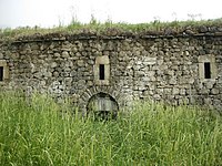
There is a 17th/18th-century Armenian monastery in the village.
Demographics
The National Statistical Service of the Republic of Armenia (ARMSTAT) reported its population as 343 in 2010,[3] down from 382 at the 2001 census.[4]
Gallery
-
 Kusanats Anapat church
 -
 Scenery
 -
 Kusanats Anapat church
 -
 Kusanats Anapat church
 -
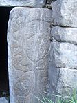 Kusanats Anapat tomb


References
Wikimedia Commons has media related to Alvank.
- ^ "Syunik regional e-Governance System" (in Armenian). Syunik Province provincial government. Click on link entitled "Համայնքներ" (community) and search for the place by Armenian name.
- ^ Statistical Committee of Armenia. "The results of the 2011 Population Census of the Republic of Armenia" (PDF).
- ^ "Marzes of Armenia and Yerevan City in Figures, 2010" (PDF). Statistical Committee of Armenia.
- ^ Report of the results of the 2001 Armenian Census, Statistical Committee of Armenia
- v
- t
- e
Capital: Kapan

- Achanan
- Agarak
- Aghvani
- Antarashat
- Arajadzor
- Artsvanik
- Bargushat
- Chakaten
- Chapni
- Davit Bek
- Ditsmayri
- Dzorastan
- Geghanush
- Gomaran
- Kaghnut
- Khdrants
- Khordzor
- Nerkin Hand
- Nerkin Khotanan
- Norashenik
- Okhtar
- Sevakar
- Shikahogh
- Shishkert
- Shrvenants
- Srashen
- Syunik
- Sznak
- Tandzaver
- Tavrus
- Tsav
- Uzhanis
- Vanek
- Vardavank
- Verin Khotanan
- Yegheg
- Yeghvard
- Erkenants [hy]
Portal:
 Geography

 | This article about a location in Syunik Province, Armenia is a stub. You can help Wikipedia by expanding it. |
- v
- t
- e


