Akole taluka
Tehsil in Maharashtra, India
19°32′32.06″N 74°0′19.88″E / 19.5422389°N 74.0055222°E / 19.5422389; 74.0055222 India
India (2011)
Akole taluka is a taluka in Ahmednagar district in Maharashtra state of India.[1] Akole consists of many places like Harishchandragad, Kalsubai, Bhandardara (Wilson) Dam, Sandhan Valley, Vishramgad etc. which attract tourists. Akole is not only famous for its natural scenery but, many historical events are also associated with it. The Western Akole is a part of Sahyadri ranges which increase its important.
Area
The table below shows area of the taluka by land type.[2]
| Type of Land | Area (km2) | % of Total Area |
|---|---|---|
| Agriculture | 987.12 | 65.59 |
| Forest | 416.98 | 27.7 |
| Other | 100.98 | 6.71 |
| Total | 1505.08 | 100 |
Villages
There are around 191 villages in Akole taluka. For list of villages see Villages in Akole taluka.
Demographics
| Religions in Akole taluk (2011)[3] | ||||
|---|---|---|---|---|
| Religion | Percent | |||
| Hinduism | 95.66% | |||
| Islam | 2.39% | |||
| Buddhism | 1.57% | |||
| Other or not stated | 0.38% | |||
Akole taluka has a population of 291,950 according to the 2011 census. Akole had a literacy rate of 74.86% and a sex ratio of 974 females per 1000 males. 10,046 (3.44%) lived in urban areas. Scheduled Castes and Scheduled Tribes make up 4.56% and 47.86% of the population respectively.[4]
At the time of the 2011 Census of India, 96.68% of the population in the district spoke Marathi and 2.02% Hindi as their first language.[5]
Rain Fall
The table details rainfall from 1981 to 2004.[6]
| Year | Rainfall (mm) |
|---|---|
| 1981 | 404 |
| 1982 | 396 |
| 1983 | 445 |
| 1984 | 374 |
| 1985 | 184 |
| 1986 | 244 |
| 1987 | 296 |
| 1988 | 734 |
| 1989 | 444 |
| 1990 | 503 |
| 1991 | 544 |
| 1992 | 404.5 |
| 1993 | 636.3 |
| 1994 | 509.8 |
| 1995 | 374 |
| 1996 | 620 |
| 1997 | 587 |
| 1998 | 814.5 |
| 1999 | 403 |
| 2000 | 439 |
| 2001 | 473 |
| 2002 | 445 |
| 2003 | 489 |
| 2004 | 1074 |
Notable people
- Indurikar Maharaj - comedian kirtankar, and social educator[7]
See also
References
- ^ "talukas in Ahmednagar district". Archived from the original on 29 September 2011. Retrieved 22 September 2010.
- ^ "talukas geographic information". Archived from the original on 29 September 2011. Retrieved 22 September 2010.
- ^ "Table C-01 Population by Religion: Maharashtra". censusindia.gov.in. Registrar General and Census Commissioner of India. 2011.
- ^ "District Census Hand Book – Ahmednagar" (PDF). Census of India. Registrar General and Census Commissioner of India.
- ^ a b "Table C-16 Population by Mother Tongue: Maharashtra". censusindia.gov.in. Registrar General and Census Commissioner of India.
- ^ "Rainfall information of Ahemadnagar district". Archived from the original on 8 December 2015. Retrieved 22 September 2010.
- ^ Gaikwad, Anand (10 January 2019). "इंदुरीकर महाराजांचा वाढदिवस पंकजा मुंडे, थोरात, जानकरांनी केला 'एन्जाॅय'". Sarkar Nama (in Marathi). Retrieved 1 January 2021.
- v
- t
- e
District Subdivisions and Talukas in Ahmednagar district
- Akole
- Sangamner
Ahmednagar district topics | ||
|---|---|---|
| History | 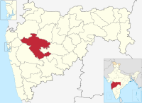 | |
| Geography | ||
| Talukas | ||
| Cities and towns | ||
| Monuments | ||
| Education | ||
| Lok Sabha constituencies | ||
| Vidhan Sabha constituencies | ||
| Dams in District | ||


