Žitorađa
You can help expand this article with text translated from the corresponding article in Serbian. (September 2013) Click [show] for important translation instructions.
- View a machine-translated version of the Serbian article.
- Machine translation, like DeepL or Google Translate, is a useful starting point for translations, but translators must revise errors as necessary and confirm that the translation is accurate, rather than simply copy-pasting machine-translated text into the English Wikipedia.
- Do not translate text that appears unreliable or low-quality. If possible, verify the text with references provided in the foreign-language article.
- You must provide copyright attribution in the edit summary accompanying your translation by providing an interlanguage link to the source of your translation. A model attribution edit summary is
Content in this edit is translated from the existing Serbian Wikipedia article at [[:sr:Житорађа]]; see its history for attribution. - You may also add the template
{{Translated|sr|Житорађа}}to the talk page. - For more guidance, see Wikipedia:Translation.
Village and municipality in Southern and Eastern Serbia, Serbia
Žitorađa Житорађа (Serbian) | |
|---|---|
Village and municipality | |
 Town panorama | |
 Flag  Coat of arms | |
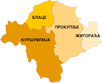
 Location of the municipality of Žitorađa within Serbia | |
| Coordinates: 43°11′N 21°43′E / 43.183°N 21.717°E / 43.183; 21.717 | |
| Country |  Serbia Serbia |
| Region | Southern and Eastern Serbia |
| District | Toplica |
| Settlements | 30 |
| Government | |
| • Mayor | Ivan Stanojević (SNS) |
| Area | |
| • Village | 21.81 km2 (8.42 sq mi) |
| • Municipality | 214 km2 (83 sq mi) |
| Elevation | 221 m (725 ft) |
| Population (2011 census)[2] | |
| • Town | 3,370 |
| • Town density | 150/km2 (400/sq mi) |
| • Municipality | 16,368 |
| • Municipality density | 76/km2 (200/sq mi) |
| Time zone | UTC+1 (CET) |
| • Summer (DST) | UTC+2 (CEST) |
| Postal code | 18412 |
| Area code | +381(0)27 |
| Car plates | PK |
| Website | www |
Žitorađa (Serbian Cyrillic: Житорађа, pronounced [ʒîtorad͡ʑa]) is a town and municipality located in the Toplica District of the southern Serbia. The municipality includes 30 settlements. According to the 2011 census, the population of the municipality is 16,368 inhabitants.
Geography
Žitorađa is 35 km to the south-west from Niš. It lies 10 km from Corridor 10, which connects Serbia with North Macedonia, Greece and further east.
Settlements
Aside from the town of Žitorađa, the municipality includes the following settlements:
- Badnjevac
- Đakus
- Debeli Lug
- Donje Crnatovo
- Donji Drenovac
- Držanovac
- Dubovo
- Glašince
- Gornje Crnatovo
- Gornji Drenovac
- Grudaš
- Jasenica
- Kare
- Konjarnik
- Lukomir
- Novo Momčilovo
- Pejkovac
- Podina
- Rečica
- Samarinovac
- Smrdić
- Stara Božurna
- Staro Momčilovo
- Studenac
- Toponica
- Vlahovo
- Voljčince
- Zladovac
History
The village has its origins in the Eastern Roman (Byzantine) town "Ad Herculum" (Ad Hercules), which existed in the 4th century. The archaeological site of the Byzantine town is known as Žitoradsko kale, located on the Pasjača mountain, while a "Latin church" dating to the period is located in Glašince.
The primary school was founded in 1873. In 1877, the region was liberated from the Ottoman Empire. This event is considered the founding year of Žitorađa municipality.
In the Expulsion of the Albanians during 1877 and 1878, many Albanians were forced to leave Žitorađa and its surroundings and became muhaxhirs.[3]
Demographics
| Year | Pop. | ±% p.a. |
|---|---|---|
| 1948 | 21,250 | — |
| 1953 | 22,427 | +1.08% |
| 1961 | 22,071 | −0.20% |
| 1971 | 21,224 | −0.39% |
| 1981 | 20,710 | −0.24% |
| 1991 | 19,545 | −0.58% |
| 2002 | 18,207 | −0.64% |
| 2011 | 16,368 | −1.18% |
| Source: [4] | ||
The municipality had 16,368 people, according to the 2011 census.
Ethnic groups
The ethnic composition of the municipality:
| Ethnic group | Population | % |
|---|---|---|
| Serbs | 14,735 | 90.02% |
| Roma | 1,366 | 8.35% |
| Montenegrins | 113 | 0.69% |
| Macedonians | 11 | 0.07% |
| Others | 143 | 0.87% |
| Total | 16,368 |
Economy
The economy of Žitorada is mostly based on agriculture.[5] There are 23,300 hectares of arable land.[5] The farm “December 1st” has the capacity of 30,000,000 fattened pigs per year, and it is one of the most successful in the whole of Serbia.[5]
The following table gives a preview of total number of registered people employed in legal entities per their core activity (as of 2018):[6]
| Activity | Total |
|---|---|
| Agriculture, forestry and fishing | 100 |
| Mining and quarrying | - |
| Manufacturing | 201 |
| Electricity, gas, steam and air conditioning supply | 10 |
| Water supply; sewerage, waste management and remediation activities | 29 |
| Construction | 138 |
| Wholesale and retail trade, repair of motor vehicles and motorcycles | 260 |
| Transportation and storage | 30 |
| Accommodation and food services | 22 |
| Information and communication | 5 |
| Financial and insurance activities | 5 |
| Real estate activities | - |
| Professional, scientific and technical activities | 45 |
| Administrative and support service activities | 20 |
| Public administration and defense; compulsory social security | 119 |
| Education | 243 |
| Human health and social work activities | 138 |
| Arts, entertainment and recreation | 28 |
| Other service activities | 23 |
| Individual agricultural workers | 266 |
| Total | 1,685 |
Gallery
-
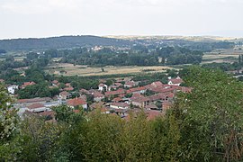
 Town panorama
 -
 Vlahovo village panorama
 -
 Church in Vlahovo
 -
 Town center
 -
 Town Sports Hall
 -
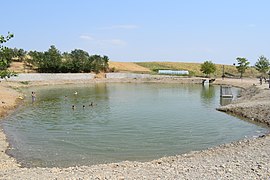 Water basin in Žitorađa


Trivia
The village was the site of the pre-ceremonial wedding of Serbian folk singer Svetlana Ražnatović "Ceca", who was born in the village, and Željko Ražnatović "Arkan", a notorious career criminal and paramilitary leader, on 19 February 1995.[7] The whole wedding was broadcast nationwide on RTV Pink.
Notable people
- Ivica Dačić (b. 1966), Serbian politician (Socialist Party of Serbia), current Minister of Internal Affairs
- Svetlana "Ceca" Ražnatović (b. 1973), Serbian folk singer popular throughout fothe rmer Yugoslavia and Bulgaria.
- Miodrag "Miki" Rakić (1975-2014), Serbian politician who played key role in reconciliation of SPS and DS and the formation of NDS and SNS, he was a former vice president of DS and chief of staff of president Boris Tadic
References
- ^ "Municipalities of Serbia, 2006". Statistical Office of Serbia. Retrieved 2010-11-28.
- ^ "2011 Census of Population, Households and Dwellings in the Republic of Serbia: Comparative Overview of the Number of Population in 1948, 1953, 1961, 1971, 1981, 1991, 2002 and 2011, Data by settlements" (PDF). Statistical Office of Republic Of Serbia, Belgrade. 2014. ISBN 978-86-6161-109-4. Retrieved 2014-06-27.
- ^ Manaj, Ramë; Osmani, Jusuf; Mekaj, Shpresa; Aliu, Bekim (2018). THE EXPULSION OF ALBANIANS FROM SANJAK OF NISH 1877/78. Prishtinë: STATE AGENCY OF KOSOVO ARCHIVES. pp. 14–26.
- ^ "2011 Census of Population, Households and Dwellings in the Republic of Serbia" (PDF). stat.gov.rs. Statistical Office of the Republic of Serbia. Archived (PDF) from the original on 29 March 2017. Retrieved 12 January 2017.
- ^ a b c "Žitorađa Official site, Information (PDF)" (PDF). Archived from the original (PDF) on 2011-12-18. Retrieved 2012-01-26.
- ^ "MUNICIPALITIES AND REGIONS OF THE REPUBLIC OF SERBIA, 2019" (PDF). stat.gov.rs. Statistical Office of the Republic of Serbia. 25 December 2019. Archived (PDF) from the original on 25 December 2019. Retrieved 28 December 2019.
- ^ Laurence Mitchell, "Serbia, 2nd", p. 49
External links
Wikimedia Commons has media related to Žitorađa.
- Official website
- v
- t
- e
 Municipality of Žitorađa
Capital: Žitorađa
- Asanovac (65)
- Badnjevac (836)
- Đakus (904)
- Debeli Lug (34)
- Donje Crnatovo (519)
- Donji Drenovac (450)
- Držanovac (947)
- Dubovo (608)
- Glašince (427)
- Gornje Crnatovo (391)
- Gornji Drenovac (420)
- Grudaš (280)
- Izvor (381)
- Jasenica (989)
- Kare (54)
- Konjarnik (104)
- Lukomir (960)
- Novo Momčilovo (85)
- Pejkovac (1276)
- Podina (798)
- Rečica (773)
- Samarinovac (756)
- Stara Božurna (358)
- Staro Momčilovo (216)
- Studenac (241)
- Toponica (329)
- Vlahovo (506)
- Voljčince (937)
- Žitorađa (3543)
- Zladovac (20)

- Svetlana "Ceca" Ražnatović
- Ivica Dačić
Municipalities and cities of Southern and Eastern Serbia | ||
|---|---|---|
| Cities |  | |
| Municipalities |
| |


